
Εκτίμηση πλημμυρικού Κινδύνου στην πόλη των Σερρών με την χρήση μορφομετρικών και υδραυλικών μοντέλων
Περίληψη
Λέξεις Κλειδιά: πλημμυρικός κίνδυνος, υδραυλικό μοντέλο, ενέργεια λεκανών, επιμήκεις τοπογραφικές τομές, Σέρρες
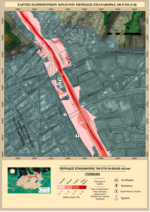
ABSTRACT: The present research aims to the evaluation of flood hazard in the city of Serres. For many years, floods occurred in this area caused serious consequences in infrastructures and civic structures. The need for a strategic prevention plan against natural hazards, led to the integration of new technologies (such as GIS and GPS) and morphometric and hydraulic models. The flood hazard assessment was initially achieved by identifying the areas, within the basins of Ag. Anargyroi and Ag.Varvara, that showed high probability of flood occurrence, and secondly, by creating flood scenarios-models on a local scale. Various methodologies including the construction of longitudinal profiles of watercourses and hydrological simulation in the selected drainage basins were applied at a regional scale (1:50.000) in order to estimate morphometric model parameters. The Hydraulic model was used in Ag.Anargyroi river using Hec-Ras in GIS environment at local scale (1:2.500). Differential GPS surveying in the area, provided high accuracy elevation data increasing the overall credibility and accuracy of the hydraulic model used. The methodologies used, helped investigate 3 different flood scenarios based on different discharge predictions (10-year, 50-years, 100-years). Flood Hazard assessment results in this case, were validated using data recorded during the 18-6-2004 flood event that occurred in the city of Serres. Validation lead to the conclusion that the methodologies used lead to credible and accurate results and can be used to evaluate flood hazard in other places.
Keywords: flood hazard, hec-ras, hec-georas, longitudinal profiles, serres, energy basinhttps://doi.org/10.26234/HEAL.IHU.DMNF-7B46
ISSN: 1792-3913
Copyright © 2010
Τμήμα Γεωπληροφορικής & Τoπογραφίας, ΤΕΙ Σερρών